Sightseeing in Wakkanai: Walking the Town of Strait and Wind at Japan’s Northern Tip
Supervised by Suzuking. (KARASU CHANNEL / Occult & horror reporting, 7 years)
Contents
Places to visit in this town (north to south)
Numbers follow the order in the article, from north to south. Select a pin to see its name. Positions are approximate.
- Cape Soya (宗谷岬) The cape at the northernmost point of mainland Japan, where on clear days the outline of Sakhalin can be seen across the strait: the end of the road for travellers.
- Soya Hills (宗谷丘陵) Japan's northernmost hill country, where Ice Age terrain survives intact; a landscape of a white road paved with scallop shells and a line of wind turbines.
- Cape Noshappu (ノシャップ岬) A cape on the northwestern edge of Wakkanai, with views on clear days of Mount Rishiri and Rebun Island floating across the sea.
- Wakkanai Park and the Gate of Ice and Snow (稚内公園と氷雪の門) A hilltop park overlooking the town and the sea, holding a memorial to those who died on Sakhalin and the memory of the Antarctic huskies.
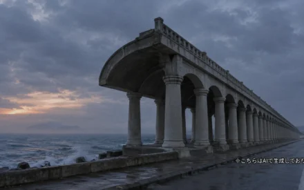
- Wakkanai Port North Breakwater Dome (稚内港北防波堤ドーム) A breakwater that sheltered Sakhalin ferry passengers from wind and snow: a 427-metre corridor lined with columns in the ancient Roman style.
- Lake Onuma (大沼) The largest lake in Wakkanai, and one of Japan's leading stopovers for swans that migrate from Siberia in winter.
Show basic information about this town (location, last checked, notes)
- Location
- Wakkanai, Hokkaido, Japan
- Last checked
- 2026.10.06
- Please note
- Opening hours, prices and closing days change often, so we do not list them. Please check each facility's official site before you go.
What Kind of Town Is Wakkanai?
Wakkanai is the city at the northern tip of Hokkaido and the centre of the Soya region. It faces the Sea of Japan to the west, the Soya Strait to the north and the Sea of Okhotsk to the east, and it sits at the northernmost point of mainland Japan, not counting the Northern Territories. From Cape Soya to Cape Nishi-Notoro on Sakhalin (樺太, Karafuto) is only about 43 kilometres, which makes Wakkanai the town in Japan closest to Sakhalin.
The name Wakkanai is thought to come from an Ainu phrase meaning “a stream of cold drinking water.” The town’s history goes back to the Soya trading post (Soya Basho, 宗谷場所) set up by the Matsumae domain in the Edo period, a key point for northern defence and trade. This article introduces the sights in order of latitude, from north to south.

A best-of collection from Sohiko Koike, known for his evidence-based reportage on the strange — a reference for our analysis pieces.
Fragments of the Uncanny: Best Reportage by ‘Occult Detective’ Sohiko Koike (Sohiko Koike & Unga Asamiya, eds. / Futami Shobo)
We may earn a referral fee on purchases made through these links.
1. Cape Soya (宗谷岬)
Cape Soya is the northernmost point of mainland Japan, and also the northernmost place an ordinary visitor can normally reach. For the record, the northernmost point under actual national control is Benten Island (弁天島), an uninhabited islet about one kilometre offshore. On a clear day, the outline of Sakhalin some 43 kilometres away can sometimes be seen.
The surrounding area has been landscaped as Cape Soya Park, with a monument marking the northernmost point of Japan and a scatter of memorials, prayer monuments and cenotaphs. The cape’s name is thought to derive from Ainu words for “chin” and “nose,” and there are several theories about the origin of “Soya,” including one that links it to a word for a rocky shore. The Cape Soya Lighthouse was first lit in 1885.
At 45 degrees north, the cape lies at roughly the same latitude as Milan in Italy, Montreal in Canada and Lyon in France. Learning that the far north of Japan shares a latitude with great cities of Europe and North America changes how the world map looks. The wind is strong and the weather can turn quickly, so dress with care.
2. Soya Hills (宗谷丘陵)
The Soya Hills stretch south of Cape Soya and are the northernmost hill country in Japan, rising from about 20 to 400 metres above sea level. The land undulates gently, with almost no deep valleys. It has been confirmed as a periglacial landscape formed in the Ice Age some 20,000 years ago, and it is designated a Hokkaido Heritage site. The point on the map marks a representative spot in the middle of the hills.
Hardly any trees grow here because forest fires in the Meiji era destroyed them, and low temperatures and strong winds have kept them from recovering to this day. Deeper in the hills runs a white unpaved road about three kilometres long, laid with crushed shells of the local scallops, and its contrast with the green grassland makes a distinctive scene.
On the ridge stands the Cape Soya Wind Farm (宗谷岬ウィンドファーム), with 57 turbines, which began operating in 2005. The electricity it generates is said to equal about 60 percent of the city’s annual consumption. Beef cattle, including the local Soya Black Cattle (宗谷黒牛), graze the pastures. Ice Age terrain and a modern way of life that harnesses the wind meet on the same hills.
3. Cape Noshappu (ノシャップ岬)
Cape Noshappu, written 野寒布岬 in kanji, lies on the northwestern edge of Wakkanai. Its name is thought to be a corruption of an Ainu phrase meaning “beside the chin (cape).” Across the bay lies Cape Soya, the northernmost point of the mainland.
Wakkanai Lighthouse stands on the cape, and on days when the sky is clear and no sea fog hangs over the water, you can see Mount Rishiri (利尻富士, Rishiri-Fuji) on Rishiri Island and Rebun Island. Whales, dolphins, orcas, seals, fur seals and Steller sea lions have all been recorded in the surrounding waters, and a monument based on an old tale of dolphins passing through the Soya Strait stands nearby.
Inland from the cape rises Mount Hera-iho (箆射峰), at 210.3 metres the highest hill within Wakkanai’s urban area. A road leads to the summit, and many visitors combine it with the cape. The sea wind can bring a chill, so it is wise to dress warmly.
4. Wakkanai Park and the Gate of Ice and Snow (稚内公園と氷雪の門)
Wakkanai Park sits on a hill overlooking the town and, together with the neighbouring forest park, covers about 100 hectares. It opened in 1954 and is known as a cherry-blossom spot in northern Hokkaido, with Yezo mountain cherries and other trees said to bloom around mid-May. In 2018 its night view was registered as a Japan Night View Heritage site.
The Gate of Ice and Snow (氷雪の門, Hyosetsu-no-Mon) in the park is a memorial to the people of Sakhalin, built in 1963. It is a place to mourn those who died on Karafuto, once Japanese territory. Two gates eight metres high flank a 2.4-metre statue of a woman at the centre. This is a place for quiet prayer, so please be respectful when you visit.
The park holds another piece of history. In 1956 a training ground was set up here for the Sakhalin huskies of the Japanese Antarctic Research Expedition, and they trained for about eight months. Memorials and a prayer tower were later built. The memory of people and dogs heading for the polar regions is carved into this northern park.
5. Wakkanai Port North Breakwater Dome (稚内港北防波堤ドーム)
The North Breakwater Dome is a large breakwater at Wakkanai Port, built over five years starting in 1931. It is about 14 metres high and 427 metres long, and its 70 columns recall ancient Roman architecture. It has been selected as a Civil Engineering Heritage site by the Japan Society of Civil Engineers and as a Hokkaido Heritage site.
It was designed by Minoru Tsuchiya (土谷実), a 26-year-old engineer with the Hokkaido Government at the time. The structure protected the pier of the Wakkanai-Korsakov ferry (稚泊連絡船, Chihaku Renrakusen), which linked Hokkaido and Karafuto, from the waves, and let passengers walk from the station to the pier sheltered from rain and wind. Rails once ran up to the front of the dome, and passengers are said to have walked along its inside to board the ship.
Even after the route to Karafuto was cut off, the structure survived and was fully renovated in 1981. This corridor, which watched over departures and farewells of people crossing the sea, quietly tells of the role Wakkanai has played. The surroundings have been developed into a park.
6. Lake Onuma (大沼)
Lake Onuma is the largest lake in Wakkanai, in the central-northern part of the city. It is a lagoon cut off from the sea by a sandbar and connected to Soya Bay through the lower reaches of the Koetoi River (声問川). The name “Onuma,” meaning “big pond,” came to be used simply because it is the biggest pond in the city.
In recent years many tundra swans have begun to arrive, making it one of the leading swan stopovers in Japan. Whooper swans, greater white-fronted geese and grey herons also visit, resting here on the way from Siberia to Lake Utonai and Lake Kutcharo. Colonies of Asian skunk cabbage can be seen around the shore.
On the north shore stands a wild bird observation centre, where you can watch the birds from an observation room. In winter, events such as driving experiences are sometimes held on the frozen surface. For migratory birds it is a resting place on a long journey. Please observe quietly so as not to startle the birds.
Local Food and Drink
The sea off Wakkanai is known for producing scallops, sea urchin, whelks, sea cucumbers and giant Pacific octopus. From spring to autumn, wild vegetables such as beach silvertop (hamabofu, ハマボウフウ) and bamboo shoots of the Kurile bamboo (chishimazasa, チシマザサ) are also gathered.
As an octopus-producing region, Wakkanai has “takoshabu” (たこしゃぶ), thin slices of octopus served shabu-shabu style, and curry that uses octopus in place of meat. Soya Black Cattle graze on the Soya Hills, and the pasteurised Wakkanai milk (稚内牛乳) is known as something you can taste only locally because of its short shelf life.
Many restaurants in Wakkanai serve chamen (炒麺), stir-fried noodles, and each place has its own character. The Yuchi potato (勇知いも) once disappeared from sale, but volunteers formed a study group and devised ways of storing it, bringing it back as a high-sugar local specialty. Shop names change easily, so this article does not list them.
Rare Wildlife and Nature
Wakkanai’s nature is defined by the Soya Hills, which preserve traces of the Ice Age, and by its windswept coast. Trees do not grow on the hills, which are covered by pasture and grassland. Summer temperatures are low, too, and days that have reached 30 degrees Celsius have been few in the past.
Across the sea, you may sometimes see Mount Rishiri, Rebun Island and the outline of Sakhalin. Lake Onuma is a stopover for migratory birds such as swans and geese. With its harsh winters, the whole city is designated a special heavy-snowfall area, with average annual snowfall of about 477 centimetres.
Around Numakawa (沼川), temperatures in the minus 28s Celsius have been recorded in some winters. Such severe nature has produced the town’s distinctive landscapes and ingredients. If you plan a winter visit, check road and weather conditions first.
Other Notable Facts About This Town
Wakkanai’s history begins in 1685, when the Matsumae domain opened the Soya trading post. Near the end of the Edo period, Mamiya Rinzo (間宮林蔵) set sail from Soya to explore Karafuto, and Matsuura Takeshiro (松浦武四郎) also left to survey it. This town was the front line of northern exploration and defence.
After the Treaty of Saint Petersburg (樺太千島交換条約) in 1875, there is a record of 841 indigenous people of Sakhalin relocating to Wakkanai. In 1923 the Wakkanai-Korsakov ferry began service, carrying traffic between Karafuto and Hokkaido until 1945. Wakkanai also flourished as a port town, the gateway to Karafuto.
In 1911 a forest fire reached the town and burned 752 houses, but it is said that, miraculously, no one died. Great fires also struck in 1928 and 1930. Each time, the town rose again.
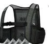
Summer ruin exploration traps heat under a roof and walls, and combined with the walk there and back, heatstroke risk runs high. An ice vest that cools your core directly just by slipping ice packs into pockets at the sides and back needs no power and layers over or under your other gear.
TULTEX Ice Cooling Vest (with 4 Ice Packs), Black AZ-865948 (Aitoz)
We may earn a referral fee on purchases made through these links.
The Night Side: Ghost Stories and Haunted Places of This Town
So far we have walked through Wakkanai’s daytime face: the northernmost cape, the Ice Age hills, the breakwater that guarded the Karafuto route, and the lake where migratory birds rest. Every one of these places overlays time in which people lived and gazed across the sea.
That depth connects to the night side as well. Wakkanai carries many layers of history, including traffic to and from Karafuto and memories of war. Ghost stories and rumours are sometimes told in connection with particular places, but we do not recommend going out to search for them. In our view, a ghost story is something like a shadow that a land’s history has cast on people’s hearts.
At KARASU CHANNEL (鴉番組), we publish true ghost stories and haunted places not for people to visit but to record them. Having learned the daytime scenery, please read the night’s tales as well.
Before You Go
Opening hours, fees, closing days and access change often, so they are not listed in this article. Before you go, please check the latest information on the official websites of each facility or local government. Some places may be closed to visitors because of weather or disasters.
Frequently Asked Questions
Q. Is Cape Soya the northernmost point of Japan?
A. It is the northernmost point of mainland Japan that visitors can ordinarily reach. In terms of the area under actual national control, the northernmost point is Benten Island, an uninhabited islet about one kilometre off the cape.
Q. In what order should I visit the sights in Wakkanai to be efficient?
A. This article introduces them from north to south. They are easiest to cover in three groups: Cape Soya and the east side of the Soya Hills; the urban area around Cape Noshappu, Wakkanai Park and the North Breakwater Dome; and Lake Onuma. The distances are considerable, so please check transport and seasonal road conditions in official guides.
Q. Is it all right to visit in winter?
A. Wakkanai is a special heavy-snowfall area, and winters bring strong winds and severe cold. Check road and transport conditions, dress thoroughly for the cold, and make a plan that does not push your limits.
Official sites and references consulted
https://ja.wikipedia.org/wiki/稚内市
https://ja.wikipedia.org/wiki/宗谷岬
https://ja.wikipedia.org/wiki/宗谷丘陵
https://ja.wikipedia.org/wiki/宗谷岬ウインドファーム
https://ja.wikipedia.org/wiki/野寒布岬
https://ja.wikipedia.org/wiki/稚内公園
https://ja.wikipedia.org/wiki/氷雪の門
https://ja.wikipedia.org/wiki/北防波堤ドーム
https://ja.wikipedia.org/wiki/大沼_(稚内市)
https://ja.wikipedia.org/wiki/稚内港

Supervised by Suzuking.
Affiliation: KARASU CHANNEL
Occult & horror reporting: 7 years (since 2020)
Followers: YouTube 5,000+ / X 25,000+
On-site investigations: 30+
Haunted locations near this town
Besides its daytime face, this land has a night side too. Read it as a record if you are curious. Some of these places are not safe or permitted to enter.